Contact Us
    • Home
    • About
      • About Us
      • Our Team
      • News & Views
      • Newsletters
      • Events
      • Our Sustainability and Environmental Goals
      • Customer Case Studies
      • Careers
      • Contact Us
    • Industries
      • Overview
      • Ports and Harbours
      • Maritime Pilotage
      • Offshore Renewables
      • Governments and Agencies
      • Customer Case Studies
      • MEMS Framework for UKHO
      • Data as Infrastructure
    • Compliance
      • Compliance Overview
      • Marine Data Management
      • Asset Management System (AMS)
      • Aids to Navigation Management System
      • Conservancy Management
      • Spatial Data Management & GIS
      • Environmental Monitoring
      • Our Courses
    • Monitoring
      • Overview
      • Monitoring System Builder
      • Data Management and Display
      • Port-Log
      • Consultancy and Advice
      • Design and Integration
      • Installation and Maintenance
      • Environmental Conditions
      • Projects
    • Mapping
      • Overview
      • Marine Themes Vector
      • Marine Themes DEM
      • ENC Web Map Service
      • Raster Charts
      • Mapping Support
    • Training
      • Our Courses
      • Data Management
      • Data Management for Ports
      • Data Management, Governance and MEDIN toolset
      • Data Management and Marine Spatial Data Infrastructure (SDI)
      • Technical Training
      • Product Training
    • Partners
      • Licenced Partner Programme
      • Partner’s Resource Hub
    • Support
      • Resources
      • Support
      • Sustainability and Environmental Goals
      • Contact Us
banner
When you need to acquire, manage, use and share marine environmental data

When you need to acquire, manage, use and share marine environmental data

Enjoy the confidence of working with marine data experts

Learn More

When you need to acquire, manage, use and share marine environmental data

When you need to acquire, manage, use and share marine environmental data

Enjoy the confidence of working with marine data experts

Learn More

Ocean Wise News

Connecting Land and Sea for Global Awareness

OceanWise > OceanWise News & Views > Uncategorised > Connecting Land and Sea for Global Awareness
A summary of Phase 4 of the Federated Marine Spatial Data Infrastructure (MSDI) Pilot

The Federated Marine Spatial Data Infrastructure Pilot is an Open Geospatial Consortium (OGC) Innovation Programme initiative that aims to enhance the understanding and uptake of MSDI and demonstrate the power of Findable, Accessible, Interoperable, Reusable (FAIR) data in the context of the marine environment. These aims parallel MEDIN’s aims but with a focus on marine geospatial data standards and technologies.

Phase 4: Connecting Land and Sea for Global Awareness’

The latest phase of the pilot (Phase 4) entitled ‘Connecting Land and Sea for Global Awareness’ is being sponsored by the Maritime Port Authority of Singapore (MPA), the US National Oceanic and Atmospheric Administration (NOAA), the Canadian Hydrographic Service (CHS) and the UK Hydrographic Office (UKHO) and involves participants including MEDIN and OceanWise Ltd.
Phase 4 aims to build on the success of the first three phases – an initial MSDI Concept Development Study, the individually themed Maritime Limits and Boundaries (MLB) Pilot, and the development of a more generic Arctic Spatial Data Pilot– and comprises three areas of interest (selected by the sponsors) with common threads (Figure1).


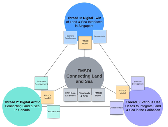
Figure 1 – Technical Architecture of the FMSDI Pilot

As with similar OGC initiatives, the pilot aims to establish interoperability through the application of state-of-the-art concepts and technologies in the form of an engineering report and several scenario-based demonstrators (and use cases) from global community experts showcasing how using OGC, IHO, and other open standards can enable the marine and maritime communities to find, obtain, use, share, interoperate, and re-use data.

One such technology is the OceanWise’s Marine Themes dataset which utilises source data from responsible authorities and unencrypted navigational data from hydrographic offices. Marine Themes, already available and used widely across the regulatory and energy sectors in the UK, NW Europe, and the Middle East (Figure 2), will be created for selected Caribbean Islands, thus testing the accessibility and efficacy of the required data inputs for use in various scenarios and the ease by which Marine Themes can be mapped onto International Hydrographic Organisation (IHO) S-100 based specifications, such as the MLB specification (S-121). Demonstrators will be prepared and hopefully made available publicly, each one focused on a particular scenario, such as renewable energy development, human health, and emergency planning and response.


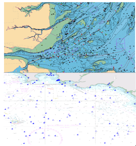
Figure 2 – Examples screenshots of OceanWises’ Marine Themes

The various data inputs – and therefore Marine Themes – will be tested for land-sea interoperability and the sources assessed against the Integrated Geospatial Information Framework Marine Maturity Index (IGIF-M) and Operational Framework (IGIF-H) recently published by the UN Committee of Experts on Global Geographic Information Management (UN-GGIM). It is hoped the pilot will lever the IGIF and promote the benefits of FAIR principles, with the aim of improving how datasets are managed and shared by data holders. Outputs from the pilot will include lessons learned and identified gaps to inform the development of relevant OGC and IHO standards.

Written by Mike Osborne, CFO and co-founder of OceanWise Ltd

Back to News

News Archive

  • May 2025
  • April 2025
  • March 2025
  • February 2025
  • January 2025
  • December 2024
  • November 2024
  • October 2024
  • September 2024
  • July 2024
  • June 2024
  • May 2024
  • March 2024
  • February 2024
  • January 2024
  • December 2023
  • November 2023
  • October 2023
  • September 2023
  • August 2023
  • July 2023
  • June 2023
  • May 2023
  • April 2023
  • March 2023
  • February 2023
  • January 2023
  • December 2022
  • November 2022
  • October 2022
  • September 2022
  • August 2022
  • July 2022
  • June 2022
  • May 2022
  • April 2022
  • February 2022
  • January 2022
  • December 2021
  • November 2021
  • October 2021
  • September 2021
  • August 2021
  • July 2021
  • June 2021
  • May 2021
  • April 2021
  • March 2021
  • February 2021
  • January 2021
  • December 2020
  • November 2020
  • October 2020
  • September 2020
  • August 2020
  • July 2020
  • May 2020
  • April 2020
  • March 2020
  • February 2020
  • January 2020
  • December 2019
  • November 2019
  • September 2019
  • August 2019
  • July 2019
  • June 2019
  • May 2019
  • April 2019
  • March 2019
  • February 2019
  • January 2019
  • December 2018
  • November 2018
  • October 2018
  • September 2018
  • August 2018
  • July 2018
  • March 2018
  • February 2018
  • December 2017
  • November 2017
  • October 2017
  • September 2017
  • August 2017
  • July 2017
  • May 2017
  • March 2017
  • February 2017
  • January 2017
  • December 2016
  • November 2016
  • October 2016
  • September 2016
  • June 2016
  • May 2016
  • April 2016
  • March 2016
  • January 2016
  • December 2015
  • November 2015
  • October 2015
  • September 2015
  • July 2015
  • June 2015
  • April 2015
  • March 2015
  • February 2015
  • December 2014
  • November 2014
  • October 2014
  • July 2014
  • June 2014
  • September 2012
  • April 2012
  • February 2012
  • December 2011
  • November 2011
  • September 2011
  • August 2011
  • July 2011
  • March 2011

© OceanWise 2025. OceanWise Limited is an independent company specialising in environmental monitoring solutions, accurate marine mapping data and expert data management services.
Registrar of Companies of England and Wales No. 7206926 and Companies Registration Office Ireland No. 641571.

Terms & Conditions | Privacy Notice | Contact Us

OceanWise HelpBot

Still need help?