Oceanwise Logo
LinkedIn Logo Twitter Logo
Log into Port-Log.net
Contact Page
+44 (0) 1420 768262
    • Home
    • About
      • About Us
      • News & Views
      • Events
      • Newsletters
      • Partners
      • Customer Case Studies
      • Professional Bodies
      • Our Team
      • Our Sustainability and Environmental Goals
      • Careers
      • Contact Us
    • Sectors
      • Overview
      • Ports and Harbours
      • Maritime Pilotage
      • Offshore Renewables
      • Governments and Agencies
      • Customer Case Studies
      • Data as Infrastructure
    • Compliance
      • Compliance Overview
      • Marine Data Management
      • Asset Management System (AMS)
      • Aids to Navigation Management System
      • Conservancy Management
      • Spatial Data Management & GIS
      • Environmental Monitoring
      • Our Courses
    • Monitoring
      • Overview
      • Monitoring System Builder
      • Data Management and Display
      • Port-Log
      • Consultancy and Advice
      • Design and Integration
      • Installation and Maintenance
      • Environmental Conditions
    • Mapping
      • Overview
      • Marine Themes Vector
      • Marine Themes DEM
      • ENC Web Map Service
      • Raster Charts
      • Mapping Support
    • Training
      • Our Courses
      • Data Management
      • Data Management for Ports
      • Data Management, Governance and MEDIN toolset
      • Introduction to Change Management
      • Capacity Building
      • Technical Training
      • Product Training
      • Our Workshops
    • Partners
      • Overview
      • Become a Partner
      • Find a Partner
      • The OceanWise Resource Hub
    • Support
      • Resources
      • Downloads
      • Portal
      • Support
      • Glossary of Terms
      • Contact Us
      • Terms and Conditions
banner
Marine mapping data that is fit for purpose, in the right format, accurate and up to date

Marine mapping data that is fit for purpose, in the right format, accurate and up to date

Intelligent marine and coastal mapping data

Marine mapping data that is fit for purpose, in the right format, accurate and up to date

Marine mapping data that is fit for purpose, in the right format, accurate and up to date

Intelligent marine and coastal mapping data

Learn More

Raster Charts Overview

OceanWise > Mapping Data Overview > Raster Charts Overview

Our Raster Charts are electronic versions of the familiar nautical paper charts and are ideal for use as a base map or a simple nautical chart background. Raster Charts can be opened using any image viewer software and are available as individual charts for different geographic areas at discrete scale levels.


Read more

Raster Charts are ideal for use as a:

  • Base / background map
  • Reference dataset
  • Simple nautical chart background
Technical Details
  • Easily opened using an image viewer software
  • Available as individual charts for different geographic areas at discrete scale levels
  • Supplied in GIS compatible file formats (GeoTIFF)
  • Supplied as individual charts
  • Available for consumption quickly after purchase with no complicated setup or wait period

OceanWise obtain Raster Charts under licence from the UK, and other, Hydrographic Offices. Availability is dependent on permissions granted by contributing nations worldwide.

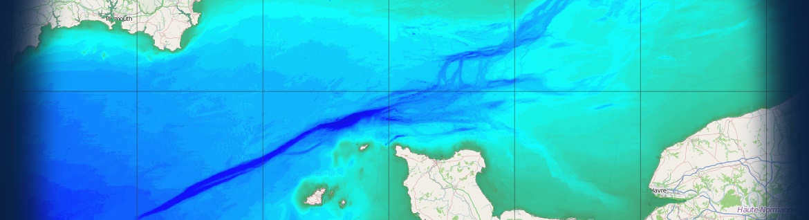
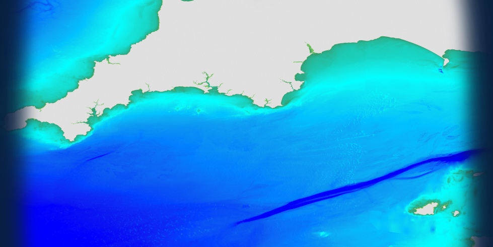
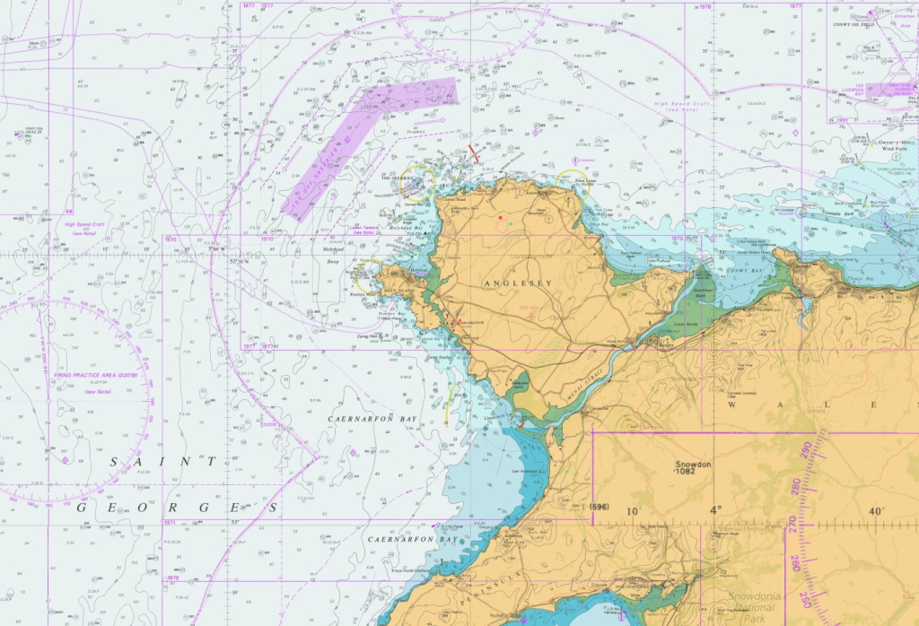
Raster Charts are derived from raster-based material obtained under licence from the UK, and other, Hydrographic Offices. They provide familiarity for users who work with nautical charts, are pre-symbolised and ready for immediate use.

We have three Raster Chart options to choose from:


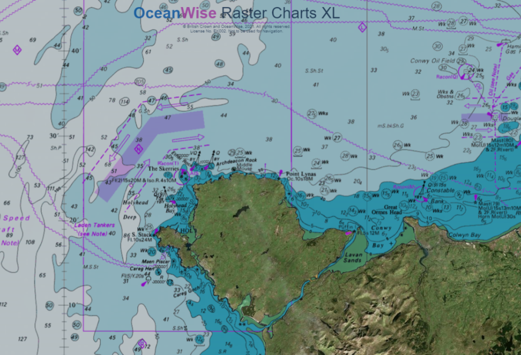
Raster Charts eXcluding Land (XL) – Our standard Raster Chart with the land carefully snipped out so that it can be paired with your choice of land mapping to create the perfect background map. Ready for immediate use in GIS or other applications.


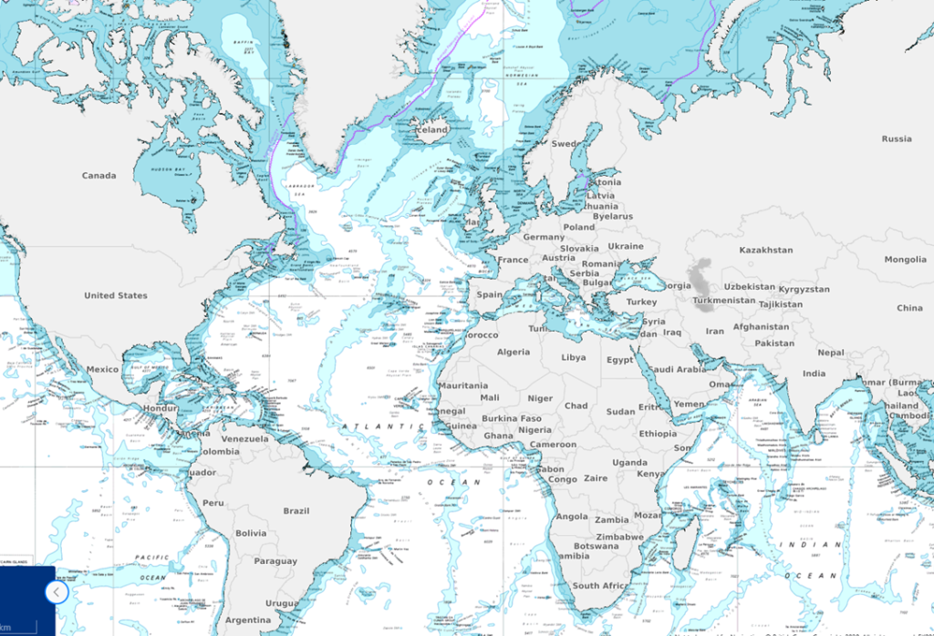
Raster Charts eXcluding Land Oceans – A global Raster Chart dataset of the worlds oceans. As with our other XL product the land has been carefully snipped out so that you can pair it with your preferred land mapping. Ready for immediate use in GIS or other applications.


Standard Raster Charts – Our standard Raster Chart product ready for immediate use in GIS or other applications.


How much do they cost / how do I buy?

Raster Charts are priced per chart. Prices vary depending on the area and scale required.


Read more

Commercial customers can purchase our mapping products via our Licensed Partners who resell our data products. Click on any of our mapping partners below to be redirected to their website or for more details, see our Find A Partner page.

If your needs are more complex, you need help in choosing your product or you are Government/Academia/ NGOs please contact OceanWise directly.

Click on below logos

emapsite
Find_Maps
Europa_Technologies

DigiMap_Jersey
DigiMap_Guernsey

Learn More

  • OceanWise Mapping Demo
  • Mapping Data FAQs
  • Raster Charts eXcluding Land (XL)
  • Raster Charts XL Oceans
  • Mapping Data Buying Guide
  • Mapping Data Products Brochure

SeaRoc

OceanWise remove all the effort by producing a complete data set that we require. It gives us accurate location and situational awareness in an easy to use format

Amanda Forbes - GIS Analyst and Developer

Lloyd's Register

Other suppliers may have the raw data but they haven't solved the big problem of joining all those hydrographic charts together - that's the value of the OceanWise product

Sam Franklin - IRIS & Web Services Product Manager

Why OceanWise?

We are proud to be: Independent. Experienced. Innovative. International. Trusted.

ISO 9001ISO 14001ISO 45001cyberessentials certification

© OceanWise 2023. OceanWise Limited is an independent company specialising in marine environmental data acquisition, management, publishing and GIS.
Registrar of Companies of England and Wales No. 7206926 and Companies Registration Office Ireland No. 641571.

Terms & Conditions | Privacy Notice | Contact Us

OceanWise HelpBot

Still need help?