Oceanwise Logo
LinkedIn Logo Twitter Logo
Log into Port-Log.net
Contact Page
+44 (0) 1420 768262
    • Home
    • About
      • About Us
      • News & Views
      • Events
      • Newsletters
      • Partners
      • Customer Case Studies
      • Professional Bodies
      • Our Team
      • Our Sustainability and Environmental Goals
      • Careers
      • Contact Us
    • Sectors
      • Overview
      • Ports and Harbours
      • Maritime Pilotage
      • Offshore Renewables
      • Governments and Agencies
      • Customer Case Studies
      • Data as Infrastructure
    • Compliance
      • Compliance Overview
      • Marine Data Management
      • Asset Management System (AMS)
      • Aids to Navigation Management System
      • Conservancy Management
      • Spatial Data Management & GIS
      • Environmental Monitoring
      • Our Courses
    • Monitoring
      • Overview
      • Monitoring System Builder
      • Data Management and Display
      • Port-Log
      • Consultancy and Advice
      • Design and Integration
      • Installation and Maintenance
      • Environmental Conditions
    • Mapping
      • Overview
      • Marine Themes Vector
      • Marine Themes DEM
      • ENC Web Map Service
      • Raster Charts
      • Mapping Support
    • Training
      • Our Courses
      • Data Management
      • Data Management for Ports
      • Data Management, Governance and MEDIN toolset
      • Introduction to Change Management
      • Capacity Building
      • Technical Training
      • Product Training
      • Our Workshops
    • Partners
      • Overview
      • Become a Partner
      • Find a Partner
      • The OceanWise Resource Hub
    • Support
      • Resources
      • Portal
      • Support
      • Glossary of Terms
      • Contact Us
      • Terms and Conditions
banner
Training from the marine data experts on data management, policy, strategy and systems

Training from the marine data experts on data management, policy, strategy and systems

Training, consultancy and advice on marine data management

Training from the marine data experts on data management, policy, strategy and systems

Training from the marine data experts on data management, policy, strategy and systems

Training, consultancy and advice on marine data management

Learn More

    Poor data management can put your operations at risk. Read our top tips to achieving marine data management success now.

    If you would NOT like to receive additional marketing communications from us that we feel are relevant to your organisation then please tick the relevant boxes below:

    OceanWise collects and processes your data according to our privacy notice. You can unsubscribe or change your preferences at any time by using the preferences link or opt-out option that will appear in every email we send to you, or by emailing us at info@oceanwise.eu.

Data Management and Marine Spatial Data Infrastructure (SDI) OR “Capacity Building” Courses

OceanWise > Training Overview > Data Management and Marine Spatial Data Infrastructure (SDI) OR “Capacity Building” Courses
Marine Spatial Data Infrastructure (MSDI) OR "Capacity Building" Courses

Who is it for / What will I learn?

We have developed a range of courses specifically for the International Hydrographic Organisation’s (IHO) Worldwide Capacity Building Programme

These courses provide vital training to Regional Hydrographic Commission (RHC) members on the subjects of Data Management, Database Design as well as developing Marine Spatial Data Infrastructures (MSDI). Our below courses can also be run as part of the FIG/IHO/ICA International Advisory Board on Standards of Competence for Hydrographic Surveyors – Category B Courses, in the UK and Europe.


Read more

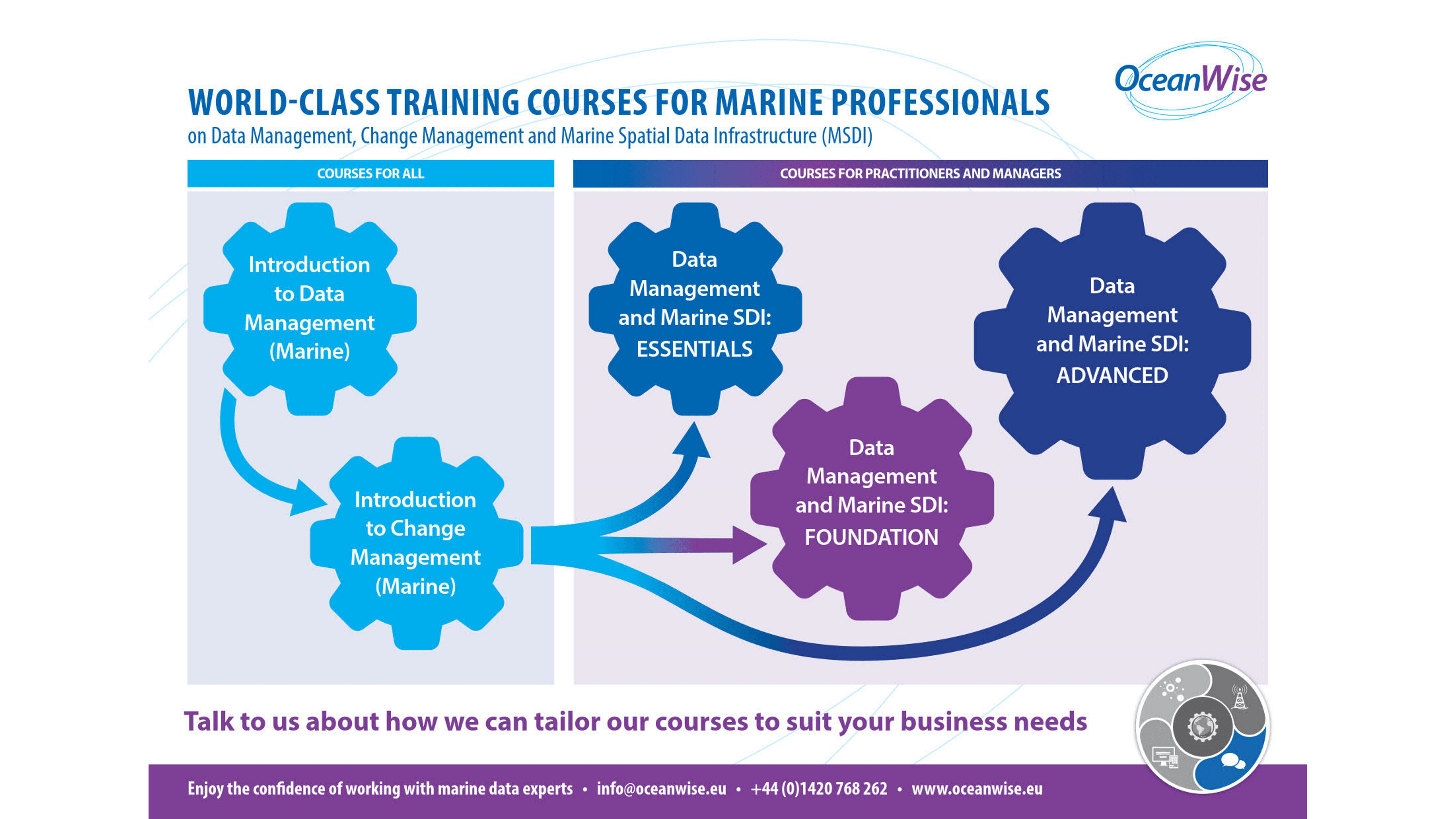
Our “Capacity Building” course provides training on Data Management, Database Design and the Marine Spatial Data Infrastructure. The aim of the programme is to enable greater access to, and sharing and exchange of geospatial data at an organisational, country or regional level, in a way that promotes and delivers ‘best practice’ across multiple stakeholders. These courses are designed for marine professionals and cover data management and the four pillars of MSDI, namely Content (Data), Standards and Specifications, Technology (ICT) and Governance (People and Organisations).

Below is our list of ‘off the shelf’ courses but we can also offer bespoke training courses on this subject on request:

  • Data Management and Marine SDI: ESSENTIALS

  • Read more

    This is a 1-day workshop, which we have successfully delivered to many national Hydrographic Offices and commercial companies across the world. It covers the four pillars of MSDI and how these crucial elements need to interact to ensure MSDI can be successfully delivered. This course is aimed at practitioners and middle managers. See our Training Guide for more details and modules covered in this course.

  • Data Management and Marine SDI: FOUNDATION

  • Read more

    This is a 2-day course has been created for managers working with, or intending to work, with geospatial, operational or business data, who wish to gain a fundamental understanding of Data Management and Governance and MSDI from a management and / or decision-making perspective. This course includes training on data management, data governance, data quality, data publishing and MSDI. It specifically includes a module on Data Policy and Strategy. See our Training Guide for more details and modules covered in this course.

  • Data Management and Marine SDI: ADVANCED

  • Read more

    This can be delivered as either a 3, 4 or 5 day course, covering theoretical and practical modules on data management, database design, data publishing and MSDI. It is aimed at practitioners who are working, or intend to work, with geospatial, operational or business data in government or commercial companies. The training examines data and its constituent elements including governance, life-cycle, quality, management and metadata. We also focus on how organisational culture and individuals respond to the changes necessary to adopt a ‘data centric’ approach to their operations. We have delivered this training across the world on behalf of the International Hydrographic Organisation (IHO) through its capacity building programme and to individual government departments and agencies and has consistently received high scores. The 4 and 5 day options allow for more in depth discussions, practical / breakout sessions. See our Training Guide for more details and modules covered in this course

    When are they held?

    We run these courses throughout the year and they are usually run on site (at a venue of the client choice) both in the UK and abroad. Contact us for availability. Contact Us for availability.

    What are the costs

    IHO members at £475 + VAT per tutor, per day (12 people to 1 tutor) + expenses

    How do I book?

    Contact us on info@oceanwise.eu or +44 (0) 1420 768262

    See our Training Guide for more details and modules covered in each course.

    Get our top tips for success

    Poor data management can put your operations at risk. Download our ‘Top tips to achieving marine data management success’ for an overview of what steps you need to take to improve your data management.

    Top tips to achieving Marine Data Management success

    Contact Us

    Contact us and we’d be happy to discuss your needs related to improving data management in your organisation.

    Contact Us

    Learn More

    • Our Courses
    • Introduction to Data Management (Marine)
    • Cadcorp GIS (Technical Training)
    • OceanWise Product Training
    • Our Workshops
    • Training, Capacity Building and Mentoring Brochure
    • Training Buying Guide

    International Hydrographic Organisation

    The work that OceanWise does in data management epitomises the way in which the hydrographic community should be moving in the twenty first century.

    Robert Ward - President

    ABP Southampton

    A good overview of the huge topic of data management with lots of ideas to take back to the workplace and to start to implement.

    Becky Conway - Principal Hydrographic Surveyor

    Global Spatial Data Infrastructure (GSDI) Association

    Thank you guys, the Marine SDI workshop discussion groups were brilliant. The explanations of what an SDI is all about were easily understood and the interactive break-out sessions helped people identify with their day to day challenges and how they might be addressed.

    Roger Longhorn - Secretary-General

    ABP Southampton

    The 'Introduction to GIS' course provided by OceanWise was much more useful than the vendor specific course as it had a marine focus and related much more to the work I do day to day.

    Sam Quilliam - Hydrographic Surveyor

    Port Training

    OceanWise made what is a dry topic very accessible to the people who need to implement it, and certainly aroused interest from the group present – who, when they become harbour masters in their own right, will need to address this issue

    Jonathan Warren

    Why OceanWise?

    We are proud to be: Independent. Experienced. Innovative. International. Trusted.

    ISO 9001ISO 14001ISO 45001cyberessentials certification

© OceanWise 2023. OceanWise Limited is an independent company specialising in marine environmental data acquisition, management, publishing and GIS.
Registrar of Companies of England and Wales No. 7206926 and Companies Registration Office Ireland No. 641571.

Terms & Conditions | Privacy Notice | Contact Us

OceanWise HelpBot

Still need help?