Oceanwise Logo
LinkedIn Logo Twitter Logo
Log into Port-Log.net
Contact Page
+44 (0) 1420 768262
    • Home
    • About
      • About Us
      • News & Views
      • Events
      • Newsletters
      • Partners
      • Customer Case Studies
      • Professional Bodies
      • Our Team
      • Our Sustainability and Environmental Goals
      • Careers
      • Contact Us
    • Sectors
      • Overview
      • Ports and Harbours
      • Maritime Pilotage
      • Offshore Renewables
      • Governments and Agencies
      • Customer Case Studies
      • Data as Infrastructure
    • Compliance
      • Compliance Overview
      • Marine Data Management
      • Asset Management System (AMS)
      • Aids to Navigation Management System
      • Conservancy Management
      • Spatial Data Management & GIS
      • Environmental Monitoring
      • Our Courses
    • Monitoring
      • Overview
      • Monitoring System Builder
      • Data Management and Display
      • Port-Log
      • Consultancy and Advice
      • Design and Integration
      • Installation and Maintenance
      • Environmental Conditions
    • Mapping
      • Overview
      • Marine Themes Vector
      • Marine Themes DEM
      • ENC Web Map Service
      • Raster Charts
      • Mapping Support
    • Training
      • Our Courses
      • Data Management
      • Data Management for Ports
      • Data Management, Governance and MEDIN toolset
      • Introduction to Change Management
      • Capacity Building
      • Technical Training
      • Product Training
      • Our Workshops
    • Partners
      • Overview
      • Become a Partner
      • Find a Partner
      • The OceanWise Resource Hub
    • Support
      • Resources
      • Downloads
      • Portal
      • Support
      • Glossary of Terms
      • Contact Us
      • Terms and Conditions
banner
When you need to acquire, manage, use and share marine environmental data

When you need to acquire, manage, use and share marine environmental data

Enjoy the confidence of working with marine data experts

Learn More

When you need to acquire, manage, use and share marine environmental data

When you need to acquire, manage, use and share marine environmental data

Enjoy the confidence of working with marine data experts

Learn More

Ocean Wise News

Launch of ‘Raster Charts XL Oceans’ imminent!

OceanWise > OceanWise News & Views > Uncategorised > Launch of ‘Raster Charts XL Oceans’ imminent!

We are eagerly anticipating the launch of our product extension to Raster Charts XL called Raster Charts XL ‘Oceans’, a global dataset which provides a contextual, authoritative ocean-wide resource ready to be paired with global land mapping of the user’s choice e.g. Open Street Map. The dataset is ideal for use as a familiar global base map of the world oceans in desktop and web GIS. It is being launched down to a scale of 1:3.5 Million. Watch out for our product bulletin coming soon…

What is Raster Chart eXcluding Land (XL)?

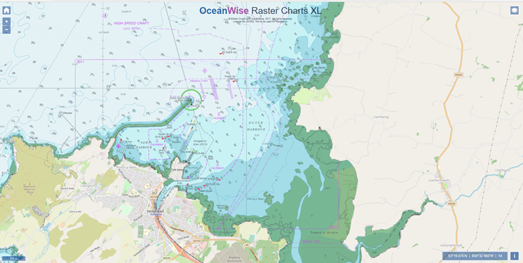
Raster Charts XL are just like standard Raster Charts but we have cleverly snipped out all the land and replaced it with clear pixels -why? Because the land on standard Raster Charts is a monotone yellow colour with very little detail, so whilst you have a great map of the marine area, you have a substandard map for the land and land based features. By removing the land and providing it as clear pixels we allow the user to insert their own preferred land data (i.e. Ordnance Survey maps, Open Street Map, aerial imagery or any others). The end result is a raster chart that has all the essential detail areas without having to compromise on the land.

Have you seen our mapping demo site? Please click here

Why choose Raster Charts XL?

  • Non-marine areas are provided as transparent pixels to allow the inclusion and display of digital land mapping, such as from a National Mapping Agency, Open Street Map or Google Maps.
  • Land and other non-marine features have been removed
  • Available is GIS compatible file formats, charts, panels or as seamless data services
  • Immediate image which is symbolised and ready to use
  • No additional software is required to open in any image viewer

How do we select our Raster Charts XL coverage?

Raster Charts XL provides a seamless base map at standard zoom level. Individual charts are carefully selected and combined to best address overlaps in coverage and chart boundary issues. Larger scale zoom levels will be provided as users demand grows, subject to availability and permissions granted by the contributing nations worldwide. At present Raster Charts XL is available at all scale (or zoom) levels in Northwest Europe and the Arabian Gulf.

Want to know more? Contact Us today for more information.

Back to News

News Archive

  • January 2023
  • December 2022
  • November 2022
  • October 2022
  • September 2022
  • August 2022
  • July 2022
  • June 2022
  • May 2022
  • April 2022
  • February 2022
  • January 2022
  • December 2021
  • November 2021
  • October 2021
  • September 2021
  • August 2021
  • July 2021
  • June 2021
  • May 2021
  • April 2021
  • March 2021
  • February 2021
  • January 2021
  • December 2020
  • November 2020
  • October 2020
  • September 2020
  • August 2020
  • July 2020
  • May 2020
  • April 2020
  • March 2020
  • February 2020
  • January 2020
  • December 2019
  • November 2019
  • September 2019
  • August 2019
  • July 2019
  • June 2019
  • May 2019
  • April 2019
  • March 2019
  • February 2019
  • January 2019
  • December 2018
  • November 2018
  • October 2018
  • September 2018
  • August 2018
  • July 2018
  • March 2018
  • February 2018
  • December 2017
  • November 2017
  • October 2017
  • September 2017
  • August 2017
  • July 2017
  • May 2017
  • March 2017
  • February 2017
  • January 2017
  • December 2016
  • November 2016
  • October 2016
  • September 2016
  • June 2016
  • May 2016
  • April 2016
  • March 2016
  • January 2016
  • December 2015
  • November 2015
  • October 2015
  • September 2015
  • July 2015
  • June 2015
  • April 2015
  • March 2015
  • February 2015
  • December 2014
  • November 2014
  • October 2014
  • July 2014
  • June 2014
  • September 2012
  • April 2012
  • February 2012
  • December 2011
  • November 2011
  • September 2011
  • August 2011
  • July 2011
  • March 2011

© OceanWise 2023. OceanWise Limited is an independent company specialising in marine environmental data acquisition, management, publishing and GIS.
Registrar of Companies of England and Wales No. 7206926 and Companies Registration Office Ireland No. 641571.

Terms & Conditions | Privacy Notice | Contact Us

OceanWise HelpBot

Still need help?