Oceanwise Logo
LinkedIn Logo Twitter Logo
Log into Port-Log.net
Contact Page
+44 (0) 1420 768262
    • Home
    • About
      • About Us
      • News & Views
      • Events
      • Newsletters
      • Partners
      • Customer Case Studies
      • Professional Bodies
      • Our Team
      • Our Sustainability and Environmental Goals
      • Careers
      • Contact Us
    • Sectors
      • Overview
      • Ports and Harbours
      • Maritime Pilotage
      • Offshore Renewables
      • Governments and Agencies
      • Customer Case Studies
      • Data as Infrastructure
    • Software
      • Overview
      • Productivity Tools
      • Dredging and Licensing
      • Hydrographic Survey
      • Asset Management System (AMS)
      • Environmental Samples
      • ENC Production
      • Spatial Data Management
    • Monitoring
      • Overview
      • Data Management and Display
      • Port-Log
      • Consultancy and Advice
      • Design and Integration
      • Installation and Maintenance
      • Environmental Conditions
    • Training
      • Our Courses
      • Data Management
      • Data Management, Governance and MEDIN toolset
      • Introduction to Change Management
      • Capacity Building
      • Technical Training
      • Product Training
      • Our Workshops
    • Mapping
      • Overview
      • Marine Themes Vector
      • Marine Themes DEM
      • ENC Web Map Service
      • Raster Charts
      • Mapping Support
    • Partners
      • Overview
      • Become a Partner
      • Find a Partner
      • The OceanWise Resource Hub
    • Support
      • Newsroom
      • Downloads
      • Portal
      • Support
      • Glossary of Terms
      • Contact Us
      • Terms and Conditions
banner
When you need to acquire, manage, use and share marine environmental data

When you need to acquire, manage, use and share marine environmental data

Enjoy the confidence of working with marine data experts

Learn More

When you need to acquire, manage, use and share marine environmental data

When you need to acquire, manage, use and share marine environmental data

Enjoy the confidence of working with marine data experts

Learn More

Ocean Wise News

Making Marine Geodata fit for purpose

OceanWise > OceanWise News & Views > Uncategorised > Making Marine Geodata fit for purpose

Dr Mike Osborne and John Pepper look at the aims and objectives of the UK Working group on Marine Geospatial Information and reflect on the need for a marine geoinformation community that is forward-thinking, inclusive and responsive.

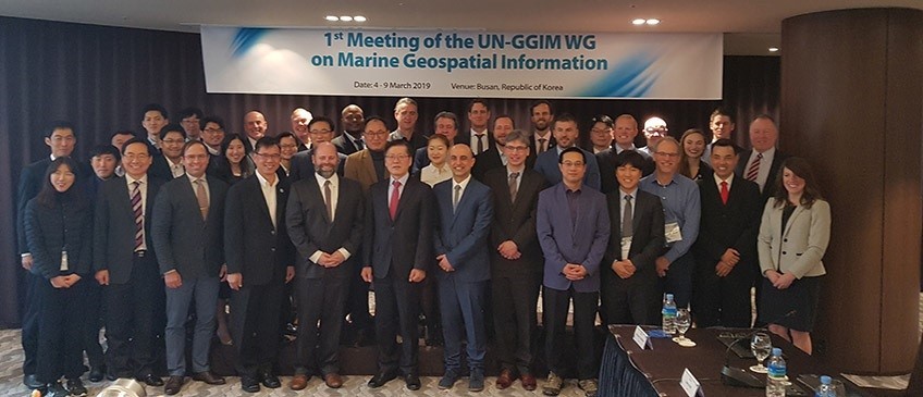
The inaugural meeting of the United Nations Working Group on Marine Geospatial Information (UN-WGMGI) took place between 4-9 March 2019 in Busan, Republic of Korea. The terms of reference of the newly formed UN-WGMGI are focussed at a policy level, raising awareness and highlighting the importance of reliable, timely and fit for purpose marine geospatial information to support the administration, management, governance of the marine environment. To deliver this, the working group is encouraging the use of internationally agreed frameworks, systems and standards to improve the relationships between people and the marine environment. It will also support the committee of experts to develop high quality and reliable regional capacity building initiatives under the UN-GGIM’s wider mantra of ‘nobody left behind’. The objectives of the UN-WGMGI mirror those exactly of the International Hydrographic Office’s Marine Strategic Development Goal (IHO-MSDI) Working Group.

To read the full article please click here

Back to News

News Archive

  • June 2022
  • May 2022
  • April 2022
  • March 2022
  • February 2022
  • January 2022
  • December 2021
  • November 2021
  • October 2021
  • September 2021
  • August 2021
  • July 2021
  • June 2021
  • May 2021
  • April 2021
  • March 2021
  • February 2021
  • January 2021
  • December 2020
  • November 2020
  • October 2020
  • September 2020
  • August 2020
  • July 2020
  • May 2020
  • April 2020
  • March 2020
  • February 2020
  • January 2020
  • December 2019
  • November 2019
  • September 2019
  • August 2019
  • July 2019
  • June 2019
  • May 2019
  • April 2019
  • March 2019
  • February 2019
  • January 2019
  • December 2018
  • November 2018
  • October 2018
  • September 2018
  • August 2018
  • July 2018
  • March 2018
  • February 2018
  • December 2017
  • November 2017
  • October 2017
  • September 2017
  • August 2017
  • July 2017
  • May 2017
  • March 2017
  • February 2017
  • January 2017
  • December 2016
  • November 2016
  • October 2016
  • September 2016
  • June 2016
  • May 2016
  • April 2016
  • March 2016
  • January 2016
  • December 2015
  • November 2015
  • October 2015
  • September 2015
  • July 2015
  • June 2015
  • April 2015
  • March 2015
  • February 2015
  • December 2014
  • November 2014
  • October 2014
  • July 2014
  • June 2014
  • September 2012
  • April 2012
  • February 2012
  • December 2011
  • November 2011
  • September 2011
  • August 2011
  • July 2011
  • March 2011

© OceanWise 2022. OceanWise Limited is an independent company specialising in marine environmental data acquisition, management, publishing and GIS.
Registrar of Companies of England and Wales No. 7206926 and Companies Registration Office Ireland No. 641571.

Terms & Conditions | Privacy Notice | Contact Us

OceanWise HelpBot

Still need help?
This website uses cookies to ensure you get the best experience... Find out more