Oceanwise Logo
LinkedIn Logo Twitter Logo
Log into Port-Log.net
Contact Page
+44 (0) 1420 768262
    • Home
    • About
      • About Us
      • News & Views
      • Events
      • Newsletters
      • Partners
      • Customer Case Studies
      • Professional Bodies
      • Our Team
      • Our Sustainability and Environmental Goals
      • Careers
      • Contact Us
    • Sectors
      • Overview
      • Ports and Harbours
      • Maritime Pilotage
      • Offshore Renewables
      • Governments and Agencies
      • Customer Case Studies
      • Data as Infrastructure
    • Compliance
      • Compliance Overview
      • Marine Data Management
      • Asset Management System (AMS)
      • Aids to Navigation Management System
      • Conservancy Management
      • Spatial Data Management & GIS
      • Environmental Monitoring
      • Our Courses
    • Monitoring
      • Overview
      • Monitoring System Builder
      • Data Management and Display
      • Port-Log
      • Consultancy and Advice
      • Design and Integration
      • Installation and Maintenance
      • Environmental Conditions
    • Mapping
      • Overview
      • Marine Themes Vector
      • Marine Themes DEM
      • ENC Web Map Service
      • Raster Charts
      • Mapping Support
    • Training
      • Our Courses
      • Data Management
      • Data Management for Ports
      • Data Management, Governance and MEDIN toolset
      • Introduction to Change Management
      • Capacity Building
      • Technical Training
      • Product Training
      • Our Workshops
    • Partners
      • Overview
      • Become a Partner
      • Find a Partner
      • The OceanWise Resource Hub
    • Support
      • Resources
      • Portal
      • Support
      • Glossary of Terms
      • Contact Us
      • Terms and Conditions
banner
When you need to acquire, manage, use and share marine environmental data

When you need to acquire, manage, use and share marine environmental data

Enjoy the confidence of working with marine data experts

Learn More

When you need to acquire, manage, use and share marine environmental data

When you need to acquire, manage, use and share marine environmental data

Enjoy the confidence of working with marine data experts

Learn More

Ocean Wise News

OceanWise Marine GIS Workshop hailed a great success

OceanWise > OceanWise News & Views > Uncategorised > OceanWise Marine GIS Workshop hailed a great success

Independent marine data management, publishing and GIS specialist, OceanWise held its Marine GIS Workshop in London on Tuesday 18th November at the School of Economic Science to great acclaim! The free-to-attend event, themed ‘the innovative use of GIS as a powerful toolset to achieve best practice’ was full to capacity with over 80 delegates registering.

Dave Morris (Cefas) got the day got off to a great start by challenging the marine scientific community to consider ‘linking’ marine data by building on the good work already done with ‘open’ data. Using the ‘six degrees of separation’ paradigm, Dave explored the chain effect ‘of a friend of a friend’ and how that relates neatly into marine geographic data speak when discussing, for example, a fish species and its potential links to, for example; sea area, bathymetry, habitat, sex, size and catch monitoring! He concluded that, at present, it is a “bridge too far” for GIS users to provide a satisfactory outcome…but it will! API developers…where are you?

Mike Osborne gave an update on the Marine Environmental Data and Information Network (MEDIN) plans to push forward on developing core reference data layers that underpin most marine activities, most of the time. Richard Farren (OceanWise) showed how sharing and publishing real-time data on the web is capturing the imagination of hydrographic and oceanographic stakeholders whilst Jonathan Craig (Peel Ports Group) showed with video streams, a real life situation of how, by creating port Electronic Navigational Charts (pENC) for Portable Pilot Units, the pilots in Clydeport were recently able to safely tow a large bulk carrier, damaged offshore in a storm, to safety within the River Clyde.

Marine GIS event speaker

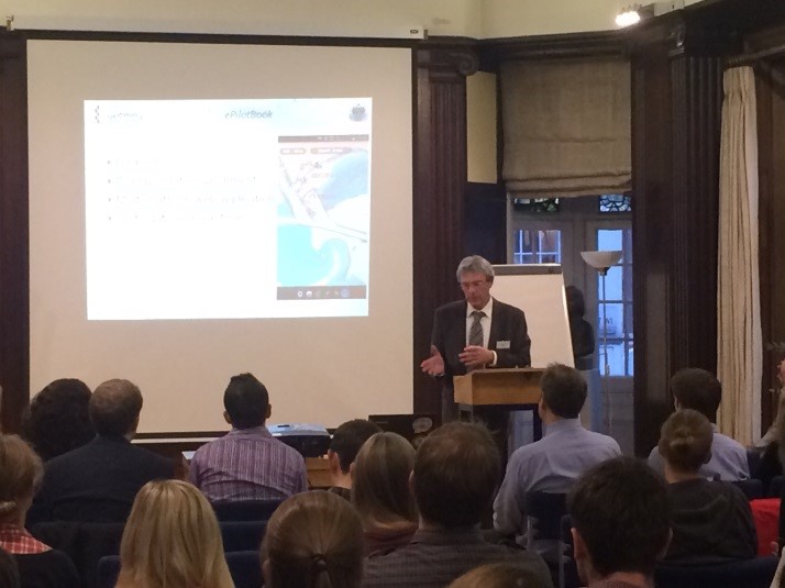
Colin Henderson (Atkins) gave a demonstration of the public facing Marine Scotland National Marine Portal (NMPi) and the innovative way in which data, web services and IT infrastructure meld to provide a simple intuitive interface understood by professionals and citizens alike.┬áPresentations by ABPMer and Fugro EMU showed how, by using GIS with OceanWise Marine Themes data as an enabler, offshore projects can be delivered more efficiently and effectively. Jon Iliffe (UCL) updated us on the workings of the UK Vertical Offshore Reference Frame (VORF) and its recent expansion as a (lower resolution) global model known as V-CAT allowing computations from offshore to 12 nautical miles from the coast. To round the day off, Claude Yvon (Geomod) demonstrated, using Marseille harbour as a case study, their ePilotBook – a multi-platform web application for port pilots.

Feedback has been extremely positive so we will be repeating the event in November 2015 – hope to see you there.

Back to News

News Archive

  • March 2023
  • February 2023
  • January 2023
  • December 2022
  • November 2022
  • October 2022
  • September 2022
  • August 2022
  • July 2022
  • June 2022
  • May 2022
  • April 2022
  • February 2022
  • January 2022
  • December 2021
  • November 2021
  • October 2021
  • September 2021
  • August 2021
  • July 2021
  • June 2021
  • May 2021
  • April 2021
  • March 2021
  • February 2021
  • January 2021
  • December 2020
  • November 2020
  • October 2020
  • September 2020
  • August 2020
  • July 2020
  • May 2020
  • April 2020
  • March 2020
  • February 2020
  • January 2020
  • December 2019
  • November 2019
  • September 2019
  • August 2019
  • July 2019
  • June 2019
  • May 2019
  • April 2019
  • March 2019
  • February 2019
  • January 2019
  • December 2018
  • November 2018
  • October 2018
  • September 2018
  • August 2018
  • July 2018
  • March 2018
  • February 2018
  • December 2017
  • November 2017
  • October 2017
  • September 2017
  • August 2017
  • July 2017
  • May 2017
  • March 2017
  • February 2017
  • January 2017
  • December 2016
  • November 2016
  • October 2016
  • September 2016
  • June 2016
  • May 2016
  • April 2016
  • March 2016
  • January 2016
  • December 2015
  • November 2015
  • October 2015
  • September 2015
  • July 2015
  • June 2015
  • April 2015
  • March 2015
  • February 2015
  • December 2014
  • November 2014
  • October 2014
  • July 2014
  • June 2014
  • September 2012
  • April 2012
  • February 2012
  • December 2011
  • November 2011
  • September 2011
  • August 2011
  • July 2011
  • March 2011

© OceanWise 2023. OceanWise Limited is an independent company specialising in marine environmental data acquisition, management, publishing and GIS.
Registrar of Companies of England and Wales No. 7206926 and Companies Registration Office Ireland No. 641571.

Terms & Conditions | Privacy Notice | Contact Us

OceanWise HelpBot

Still need help?