
In the lead up to the ban on all but essential travel, and then the initial two-month lockdown, OceanWise was putting the final touches to an environmental monitoring system that had been commissioned by a customer in 2019. This in itself was not unusual because we normally have 2-3 systems like this in various stages of design, build, test, and sometimes maintenance, in our workshop at any one time. However, this particular system was different, it was destined for Africa.
Our customer wanted to improve the monitoring of environmental conditions at their terminal and mooring buoy and had approached a number of sensor manufacturer’s who had referred them to OceanWise to come up with a suitable recommendation and design. The data was required for operational safety and planning and as input to potential development studies. The types of data required were wind and weather conditions, tide and surge water level and currents, and wave height period and direction. Importantly, our customer required the data to be accessible to operational personnel locally, but also to other personnel nearby including offshore, and at their offices around the world. The data had to be sufficiently accurate for engineering design and sufficiently reliable to support operations 24/7.
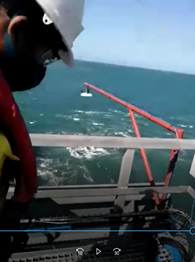
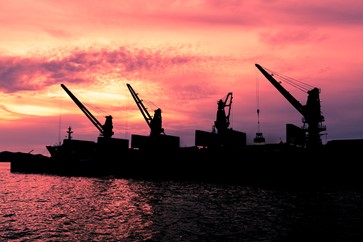
Above image: example of a previous on-site sensor installation in Ghana
Several design options were considered but ultimately the system was built using in situ sensors from Valeport and Gill Instruments, with OceanWise providing the smart telemetry unit, the ip.buffer, and the company’s online data collection, management and dissemination system, Port-Log. The use of the ip.buffer – and the ‘cloud’ version of Port-Log – was definitely a smart move because both proved invaluable in supporting the remote installation and future maintenance requirements. OceanWise’s MD, Dr Mike Osborne, explained “Being independent we are able to choose from a range of different measurement techniques and sensors that we then discuss with our customers to ensure their requirements are met within the available budget. In this case, as well as the sensors ultimately chosen, we also considered a data buoy, seabed installation, and acoustic or microwave devices from Nortek and Miros, respectively”.
So, by March 2020, the sensors had been delivered to OceanWise, the system was built and we were ready to undertake a final configuration regarding cable run lengths and undertake a Factory Acceptance Test (FAT). The site survey we had planned had to be cancelled due to Covid-19 restrictions and the FAT would need to be done on trust, unless we could somehow do this work remotely. In the lead up to full lockdown, OceanWise had already started homeworking, utilising our recent migration to Microsoft 365 and VPN access to our offices in Hampshire and online servers. This was working very well, so it didn’t seem too much of a risk to trial undertaking the site survey and FAT remotely using this technology as well.
A plan of work was prepared, including safety considerations, and the key outcomes that would have been the responsibility of the OceanWise engineer, had he (or she) been on site, were relayed to the customer’s operational personnel. Telecommunications between Africa and Hampshire were tested and seemed to give us adequate bandwidth for speech but also for video that would be essential to record all the usual aspects of a site visit. A series of online meetings were planned and undertaken successfully, and we were able to use this to record the information required, directing onsite personnel accordingly. The recordings were checked against the various drawings that we had supplied, and the customer’s personnel had annotated, but ultimately we are able to complete a Site Survey Report in the normal way.
By mid April, the final configuration, system build and tests had been completed and the system had been packaged up and was ready to ship overseas. Our next challenge was to find an agent that was able to confidently ship the equipment to a specific location from where it would be taken to site by lorry. After much chasing, and an unscheduled stay in South Africa courtesy of UPS, the equipment arrived, cleared customs and was seamlessly moved to site, but what about the actual installation? The original plan was to mobilise an OceanWise engineer to site for this too, but much of the world was still in lockdown with no sign of a reprieve, and by now our customer understandably wanted the system up and running as soon as possible.
Although the site survey had been completed almost perfectly, surely undertaking a successful installation remotely as well would be too much to ask we thought. After much consideration, planning and liaison with all teams this is exactly what we were able to do, again directing our customer’s onsite personnel accordingly. Following the process as for the site survey, a series of short online meetings were planned, each to accomplish specific tasks, such as to unpack and layout all the equipment, then to assemble, power it up and test it, including checking we were receiving data in Port-Log. We then went through what would be required to install the enclosure, radar, weather station and ultimately instruct divers to put in place the underwater fixings and sensors. This took several days during which time we were able to connect to the ip.buffer (our smart telemetry modem) remotely to test and reconfigure the system, such as being able to switch sensors to factory mode for a period to check that the quality of data was as expected.
The lesson learnt from this project is that, along with office based remote working, site survey and installation work, acceptance tests can be accomplished, but detailed planning, work instructions including items that an engineer would normally take to site as part of the system deliverable are essential. Commitment by the customer, and the expertise, cooperation and sometimes patience of onsite personnel was also essential. So, the system is in situ and working as we originally planned but we are still planning a site visit when we can to undertake a detailed check on cable protections measures etc. and training. We also plan to undertake a survey of the tide gauge from a coastal benchmark using digital levelling and GNSS so it can be used for long-term sea level monitoring. It will also allow us to say a personal hello and a big thank you to all the personnel that we have gotten to know remotely.