Join our Newsletter
Log into Port-Log.net
Contact Page
+44 (0) 1420 768262
Home
About
About Us
News & Views
Events
Newsletters
Partners
Customer Case Studies
Professional Bodies
Our Team
Our Sustainability and Environmental Goals
Careers
Contact Us
Sectors
Overview
Ports and Harbours
Maritime Pilotage
Offshore Renewables
Governments and Agencies
Customer Case Studies
MEMS Framework for UKHO
Data as Infrastructure
Compliance
Compliance Overview
Marine Data Management
Asset Management System (AMS)
Aids to Navigation Management System
Conservancy Management
Spatial Data Management & GIS
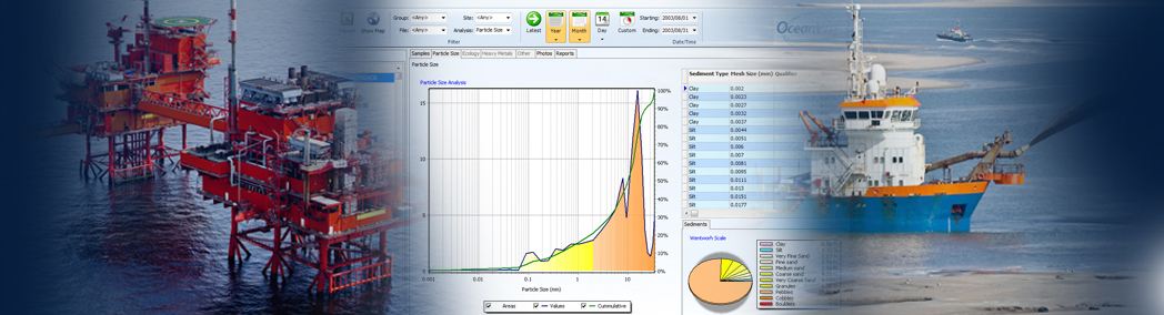
Environmental Monitoring
Our Courses
Monitoring
Overview
Monitoring System Builder
Data Management and Display
Port-Log
Consultancy and Advice
Design and Integration
Installation and Maintenance
Environmental Conditions
Mapping
Overview
Marine Themes Vector
Marine Themes DEM
ENC Web Map Service
Raster Charts
Mapping Support
Training
Our Courses
Data Management
Data Management for Ports
Data Management, Governance and MEDIN toolset
Data Management and Marine Spatial Data Infrastructure (SDI)
Technical Training
Product Training
Partners
Overview
Become a Partner
Find a Partner
The OceanWise Resource Hub
Support
Resources
Portal
Support
Glossary of Terms
Contact Us
Terms and Conditions
Simplify your approach and improve decision making and data management
Tools to manage data and assets, provide spatial awareness, and streamline processes
Simplify your approach and improve decision making and data management
Tools to manage data and assets, provide spatial awareness, and streamline processes